Gujarat Board GSEB Solutions Class 6 Social Science Chapter 7 Gujarat: Location, Boundary and Physiography Textbook Exercise Important Questions and Answers, Notes Pdf.
Gujarat Board Textbook Solutions Class 6 Social Science Chapter 7 Gujarat: Location, Boundary and Physiography
GSEB Class 6 Social Science Gujarat: Location, Boundary and Physiography Textbook Questions and Answers
1. Answer the following questions:
Question 1.
Which country is located in the north-west of India ?
Answer:
The country Pakistan is located in the north-west of India.
Question 2.
Name the gulfs in the Arabian Sea.
Answer:
The gulfs in the Arabian Sea are:
- Gulf of Kutch and
- Gulf of Khambhat.
Question 3.
Why are the plains densely populated ?
OR
Give reason: There is more population in the fertile plain.
Answer:
Best facilities for agriculture and settlement are available in fertile plains, so the plains are densely populated.
![]()
Question 4.
What is the speciality of the desert of Kutch ?
Answer:
The speciality of the desert of Kutch are:
- It is a desert even though it is not sandy.
- The entire desert region is a kharopat (salt pan).
Question 5.
Why is the coastline of Gujarat useful ?
OR
Give reason: The Gujarat coastline is useful for navigation.
Answer:
The coastline of Gujarat is about 1600 kilometres long. In comparison with other states of India, the sea coast of Gujarat is longer and less dissected. That is why it is useful for navigation.
2. Fill in the blanks by choosing the correct options:
1. The district of Gujarat with a sea boundary is ………………. . (Dahod, Mehsana, Patan. Kutch)
Answer:
Kutch
2. The river which flows in the plains of Gujarat is ………………. (Sabarmati, Yamuna, Kaveri, Godavari)
Answer:
Sabarmati
3. Gujarat’s hilly region is divided into …………….. parts. (two, three, four)
Answer:
three
4. The district of ……………….. in Saurashtra is a plateau. (Banaskantha, Mehsana, Junagadh, Gandhinagar)
Answer:
Junagadh
![]()
5. Your district is included in …………………. region of physiographical regions of Gujarat. (plains, plateaus, seashore, hilly)
Answer:
plains
GSEB Class 6 Social Science Gujarat: Location, Boundary and Physiography Intext Questions and Answers
Activity
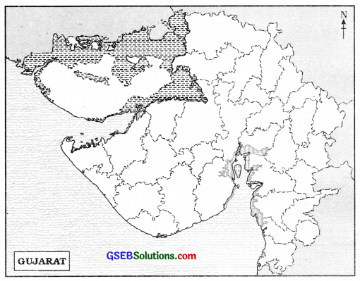
Show the following details in the outlined map of Gujarat given on page no. 102:
(1) Show your district by pink colour.
(2) Show your neighbouring districts by yellow colour and write their names.
(3) Show the boundary of Pakistan by red pencil or by red pen.
(4) Show the neighbouring states of Gujarat.
(5) Show the gulfs in the Arabian Sea.
(6) Show the Tropic of Cancer.
(7) Show the Taranga, Idar, Pavagadh, Shetrunjo, Girnar, Bhujiyo and Dhinodhar hills by ![]() symbol.
symbol.
(8) By ![]() symbol, show Kandla, Porbandar, Veraval, „ Pipavav and Magdalla ports.
symbol, show Kandla, Porbandar, Veraval, „ Pipavav and Magdalla ports.

GSEB Class 6 Social Science Gujarat: Location, Boundary and Physiography Additional Important Questions and Answers
Choose the correct alternative from those given below each question:
Question 1.
In which direction in India is Gujarat situated ?
A. South
B. North
C. West
D. East
Answer:
C. West
Question 2.
How many kilometres long is the seacoast of Gujarat ?
A. 1600
B. 1750
C. 2600
D. 1480
Answer:
A. 1600
Question 3.
Which district is situated in the north-west boundary of Gujarat ?
A. Valsad
B. Banaskantha
C. Jamnagar
D. Kutch
Answer:
D. Kutch
![]()
Question 4.
Which state in India has the longest coastline ?
A. Andhra Pradesh
B. Gujarat
C. Maharashtra
D. Tamil Nadu
Answer:
B. Gujarat
Question 5.
What is the rank of Gujarat in area among the states of India?
A. Ninth
B. Eighth
C. Fourth
D. Seventh
Answer:
D. Seventh
Question 6.
How many physiographic divisions are there in Gujarat ?
A. Five
B. Three
C. Six
D. Four
Answer:
A. Five
Question 7.
Which type of region is most of the Kutch ?
A. Valley
B. Plain
C. Desert
D. Plateau
Answer:
C. Desert
Fill in the blanks with proper words or numbers in the following statements:
1. Gujarat is situated in ………………….. direction of India.
Answer:
west
2. ……………….. district is situated in the eastern boundary of Gujarat.
Answer:
Dahod
![]()
3. …………………… district is situated in the western boundary of Gujarat.
Answer:
Jamnagar
4. ………………….. district is situated in the northern boundary of Gujarat.
Answer:
Banaskantha
5. …………………. district is situated in the southern boundary of Gujarat.
Answer:
Valsad
6. ………………….. is the western sea boundary of Gujarat.
Answer:
Arabian Sea
7. The seacoast of Gujarat is about ………………. kilometres long.
Answer:
1600
8. Gujarat has about ……………….. sq km of geographical area.
Answer:
1,96,024
9. Tropic of …………………….. passes through almost middle of Gujarat.
Answer:
Cancer
![]()
10. Most of the area of north Gujarat is a …………………. region.
Answer:
plain
11. The Kutch desert is a ………………… .
Answer:
kharopat (salt pan)
State whether the following statements are true or false:
1. Gujarat is situated to the east of India.
Answer:
False
2. Kutch district is situated to the north-west of Gujarat.
Answer:
True
3. In India, Gujarat has the shortest sea boundary.
Answer:
False
4. In terms of area, Gujarat is ninth largest state in India.
Answer:
False
![]()
5. Total geographical area of Gujarat is about 6 % of India.
Answer:
True
6. The land area of Gujarat is divided into three zones.
Answer:
False
7. Gujarat can be divided into five physiographic zones.
Answer:
True
8. Most of the area in Gujarat is hilly.
Answer:
False
9. Land in Kutch desert is mostly saline.
Answer:
True
10. On full moon day, the Kutch desert appears like a white bedcover.
Answer:
True
Answer the following questions in one or two sentences each:
Question 1.
In which direction is Gujarat situated in India ?
Answer:
Gujarat is situated in the western direction in India.
![]()
Question 2.
Between which latitudes is Gujarat located ?
Answer:
Gujarat is located between 20.06’ north latitude and 24.42’ north latitude.
Question 3.
Between which longitudes is Gujarat located ?
Answer:
Gujarat is located between 68.10’ east longitude and 74.28’ east longitude.
Question 4.
Which types of boundaries does Gujarat have ?
Answer:
Gujarat has two types of boundaries:
- Land boundary and
- Sea boundary.
Question 5.
Which districts are situated in the east, west, north, south and in the north-west of Gujarat?
Answer:
Dahod district is situated in the east, Jamnagar in the west, Banaskantha in the north, Valsad in the south and Kutch district is situated in the north-west of Gujarat.
Question 6.
Which sea is situated on the western boundary of Gujarat?
Answer:
Arabian Sea is situated on the western boundary of Gujarat.
Question 7.
How many kilometres long is the seacoast of Gujarat ?
Answer:
Gujarat has about 1600 kilometres long seacoast.
![]()
Question 8.
What is the rank of Gujarat in India in total land area?
Answer:
Gujarat ranks seventh in India in total land area.
Question 9.
How many kilometres is the north-south length and east-west width of Gujarat?
Answer:
The north-south length of Gujarat is 590 kilometres and the east-west width is 500 kilometres.
Question 10.
What is the total geographical area of Gujarat?
Answer:
The total geographical area of Gujarat is about 1,96,024 sq km.
Question 11.
Into how many zones is the land area of Gujarat divided? Which are they?
Answer:
The land area of Gujarat is divided into four zones:
- North Gujarat,
- Central Gujarat,
- South Gujarat and
- Saurashtra and Kutch.
Question 12.
Into how many physiographic divisions is Gujarat divided ?
Answer:
Gujarat can be divided into five physiographic divisions:
- Plains
- Hilly and Mountainous Areas
- Plateaus
- Deserts and
- Coastal Plains.
Question 13.
What is meant by relief features?
Answer:
Different landforms such as mountain, hill, plateau, plain, seacoast, desert, etc. are called ‘relief features’.
![]()
Question 14.
Why are the plains of Gujarat fertile?
Answer:
Rivers flowing through the plains of Gujarat have deposited alluvium, so the plains in Gujarat are very fertile.
Question 15.
Which plains of Gujarat are very fertile?
Answer:
Plains of south Gujarat and central Gujarat are very fertile.
Question 16.
Where and in how many parts are the hills of Gujarat distributed ?
Answer:
The hills of Gujarat are distributed in three zones:
- Hills of Tal Gujarat,
- Hills of Saurashtra and
- Hills of Kutch.
Question 17.
What is the type of land of Kutch?
Answer:
The type of land of Kutch is saline.
Question 18.
From which ports of Gujarat was most of the trade carried out in ancient time?
Answer:
Most of the trade in ancient Gujarat was carried out through ports such as Lothal, Khambhat, Ghogha, Bharuch, Surat.
![]()
Answer the following questions in brief:
Question 1.
Write about the coastal boundary of Gujarat.
Answer:
Arabian Sea is situated to the west of Gujarat. This coastal boundary is about 1600 kilometres long, and is the longest sea boundary in India. There are two gulfs in the Arabian Sea: Gulf of Kutch and Gulf of Khambhat.
Question 2.
State the total geographical area of Gujarat.
Answer:
Total geographical area of Gujarat is about 1,96,024 sq km. It is about 6% of total area of India. The north-south length of Gujarat is about 590 kilometres, while the east-west width is about 500 kilometres.
Question 3.
Write about the plains of Gujarat.
Answer:
Most of Gujarat is a plain region. Rivers have deposited much alluvium, so the plain is very fertile. The plain of south and central Gujarat is more fertile. As these plains have enough facilities for agriculture and for settlements, there is fairly large population. Most of the north Gujarat is a plain region.
Question 4.
Write about the hilly region of Tal Gujarat.
Answer:
The hilly region which prevails over entire eastern boundary from Banaskantha up to Valsad is known as ‘Aravalli Range’. This range includes Gabbar Hill, Taranga Hill, Idar Hill, Pavagadh Hill, Rajpipla Hills, Parnera Hill near Valsad and Saputara Hills.
Question 5.
Write about the hilly region of Saurashtra.
Answer:
The central hilly region of Saurashtra includes Chotila Hill, Bardo Hill near Porbandar, Shetrunjo Hill near Palitana and Khokhara Hill in the north of Bhavnagar.
Question 6.
Name the hills / mountains in the Kutch Gujarat Hills.
Answer:
The hills of Kutch Gujarat hills are Dhinodhar, Karo, Bhujio, Liliyo, Kanthkot hills, etc. Among these, Dhinodhar is the tallest hill.
![]()
Question 7.
What is a ‘Plateau’ ? Which part of Gujarat is known as a Plateau ?
Answer:
A large plain having an altitude of more than 190 metres and less than 900 metres is called a ‘Plateau’.
In Gujarat, central Kutch and central Saurashtra are known as ‘plateau’. The Saurashtra Plateau is higher in its central part and becomes lower towards the sea coast.
Question 6.
……………… is situated in the east, ……………. in the west, …………….. in the north, …………………. in the south and ………………. in the north-west of Gujarat.
Answer:
Madhya Pradesh, Arabian Sea, Rajasthan, Maharashtra, Pakistan (country).
Question 7.
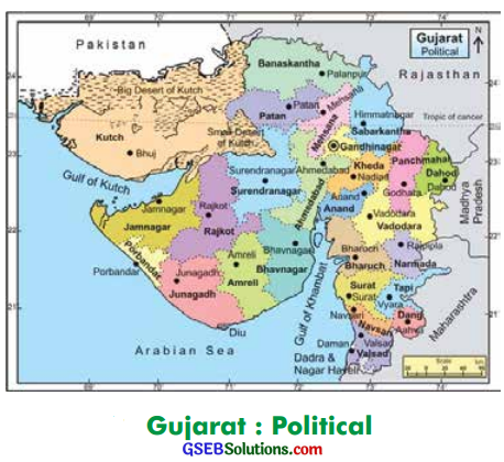
See the political map of Gujarat and write the names of the districts through which the Tropic of Cancer passes.
(1) …………….. (2) ……………….. (3) ………………. (4) …………………. and (5) ……………..
Answer:
(1) Sabarkantha
(2) Gandhinagar
(3) Mahesana
(4) Patan
(5) Kutch
Question 8.
In the table given below, write the names of the hills according to the area:
Answer:
| Hills of mainland of Gujarat | Hills of Saurashtra | Hills of Kutch |
| 1. Gabbar | 1. Chotila | 1. Bhujiyo |
| 2. Taranga | 2. Eardo | 2. Karo |
| 3. Idar | 3. Shetrunjo | 3. Liliyo |
| 4. Pavagadh | 4. Khokhara | 4. Dhinodhar |
| 5. Parnera | 5. Girnar | 5. Kanthkot |
| 6. Saputara | – | – |
Question 9.
Study the political map of Gujarat given below. Remember the names and the locations of districts, bays, Tropic of Cancer and the neighbouring states of Gujarat:
Answer:

Question 10.
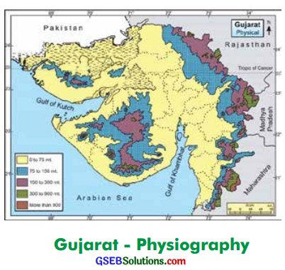
Study the physical map of Gujarat given below. Remember the names and the locations of major hills and ports given in the map:
Answer:
